Lake Bunyonyi

May 21st, 2012
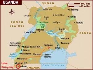
One more jaunt before we leave Uganda for now.  Our new rep arrived the first of May and is now taking over.  So we took a long weekend to visit Lake Bunyonyi.  We had earlier seen the Lake from mountains above when we drove to Rwanda in November.  We knew we wanted to return to explore it more even though it is a 7 hour drive from Kampala.

We left our car at a secure site near the lake and took a boat to our lodging—Jajama Panorama.  The “resort” is located on the side of a hill overlooking the lake.  Such beautiful views!  This is at the end of the low tourist season and we were the only ones staying; we had personal treatment!  Mercy served as our host and cooked delicious meals and Martin kept the wood fire going so that we would have hot water.

Lake Bunyonyi, located about 6000 feet altitude, is surrounded by mountains rising up to 7500 feet.  It is considered the second deepest lake in Africa and is one of the few freshwater lakes in East Africa that is considered safe (disease-free) for swimming.  We didn’t swim even though it looked inviting.  We did paddle our own dugout canoe two mornings looking for birds and enjoying the scenery and the peacefulness.  “Lake Bunyonyi” means “place of many little birds.”  We saw quite a few birds and were able to photo some of the larger ones.

We hiked around the resort.  It rained during our first night so some of the paths were a bit slippery.  Ron waited at the bottom of one small decline as Sally Jo came sliding down!

One afternoon Sally Jo hiked up the hill and along the terraces and hilltop.  She was “guided” by two primary school boys. This is a highly fertile area and farming is done on terraces.  She saw much maize, Irish potatoes, sweet potatoes, and green beans growing.  She also went out to a point where much of the lake was visible—it is a long narrow lake with many inlets and many islands.  One island is named “Punishment Island.”  [The Bakiga (ethnic group in this area) used to leave unmarried pregnant girls on this small island with a lone tree  – to die of hunger or while trying to swim to the mainland (swimming skills were rare). This was to educate the rest, to show them not to do the same. A man without cows to pay the bride price could go to the island and pick up a girl. The practice was abandoned in the first half of the 20th century.  –from Wikipedia, though we heard the story numerous times.]

We very much enjoyed the relaxing few days—scenery, birds, water, games.  Now to the final days of packing, one more all-day meeting, and final good-bys.  It has been a good 15 months here.

Cape Town

April 28th, 2012

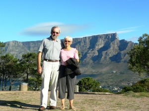
together on Signal Hill with Table Mountain in background

On our last day in South Africa we decided to pay a short visit to the town of Cape Town.  We passed the one side of the House of Parliament and the National Library Cape Town branch.  We visited St George’s Cathedral where in 1986 Desmond Tutu hammered on its doors symbolically demanding to be enthroned as South Africa’s first black archbishop.  Three years later, he “began” the last days of apartheid by leading 30,000 people from the cathedral to the City Hall in a peaceful demonstration.

We visited the Company Gardens.  Initially they were established in 1652 to supply fresh greens to Dutch East India Company ships traveling between the Netherlands and the East.   At the end of the 1600’s they were turned into a botanical garden with ponds, lawns, landscaping and oak-shaded walkways.  It was while walking along these paths in the late 1880’s that Cecil Rhodes first plotted the invasion of what is now Zimbabwe. He also introduced the small furry North American grey squirrels!

We ended our day by driving up Signal Hill with its good views over Table Bay, the docks, the city (including the 2010 World Cup Soccer stadium), and back to Table Mountain.

We had a glorious time during our two weeks.  As you can tell we spent most of our time in nature and therefore, met almost no South African people.  We also missed many historical, famous sites.  Maybe next time!

Cape of Good Hope

April 27th, 2012

Simon’s Town, several miles south of Fish Hoek along the coast, is the country’s third-oldest European settlement.  It is home to the country’s principal naval base.  Also just a few kilometers from the town is home to a colony of African penguins.  They are cute!  The penguins were smaller than we expected and were fun to watch.

We continued on down the beautiful coast to Cape of Good Hope.  We joined the crowds of tourists going up the short, steep walk on De Gama peak to the original lighthouse, built in 1860.  This lighthouse is often shrouded in cloud and failed to keep ships off the rocks so in 1914 another was built lower down and closer to the point

Cape Point is popularly believed to be the meeting place of the Atlantic and Indian Oceans, although the official meeting happens to the east at Cape Agulhas—on beyond Hermanus which we visited the first week.  At this Cape the cold Benguela current merges with the warm Mozambique current.  The bay on which Fish Hoek is located and is on the east side of the cape is called False Bay because early on, sailors sailing from the east thought they had rounded the Cape.  In fact, they had not, and in reality False Bay can be very dangerous with many hidden rocks and extremely big waves.  There are reports of many ship wrecks in the bay

We hiked from Cape Point with the lighthouse to the westerly Cape of Good Hope along the edge of the cliffs.  On our return we climbed down many steps (about 250!) to the Diaz Beach, named for Bartholomew Diaz of 1488 who is credited with the discovery of the Cape for Europeans.  (Artifacts show that the region was known and utilized since the Early Stone Age.)  We sat and rested and then stuck our toes in the ice-cold water.

Table Mountain

April 26th, 2012

The icon of Cape Town, Table Mountain rises 3300 feet above the city.  It is a flat-topped “rock” with cliffs and gorges that dominates the northern end of the peninsula.

To get there from our “home,” we travelled the Chapman’s Peak Drive along the western edge of the peninsula.  Gorgeous views of the coast and the mountains. But it was so windy that sea water was blowing off the top of the waves. Also Ron lost his favorite black cap to the cliffs off Chapman’s Peak and replaced it with a new one sporting the colors of the South African flag

We took the cable car to the top of the mountain.  The floor of this car is designed to complete a 360-degree rotation so that we could get a full panorama view on each trip—across Table Bay, the city, and the cliffs.  Once on the top we hiked to Maclear’s Beacon which is the highest point on the mountain.

Kirstenbosch

April 26th, 2012

Kirstenbosch is the oldest and largest botanical garden in South Africa, created in 1895 by Cecil Rhodes, whose camphor and fig trees are still standing.  In 2004 the gardens became an UNESCO World Heritage Site—the first botanical garden in the world to achieve this.  It recognizes the significance of the fynbos plant kingdom.  (Remember that we mentioned it already in several blogs!)  There are paved paths and many  signboards to guide you to various parts of the garden.   The gardens trail off into wild vegetation covering the slopes of Table Mountain.

We had a lovely cream tea in the restaurant—spinach quiche tarts, cucumber sandwiches, scones with jam and cream, carrot cake, and lots of tea!   We walked many miles in the garden and saw beautiful sites and learned a bit about the special vegetation region of the Cape.  Our photos do not do justice to the beauty we saw.

Fish Hoek

April 26th, 2012

We spent our last six nights in Fish Hoek (see our earlier map) on the Cape Peninsula at a self-catering flat.  It was a lovely spot.  Our flat was on second floor with a nice balcony.  Every morning we watched the sun rise over the hills on the far side of the bay.  It was beautiful.

The local passenger train (very quiet) passed between us and the shore.  It reminded us of our year in Nottingham, England when we had a train in our back yard.  It makes for very easy commuting.

There are sharks in these waters but we didn’t see any.  From our balcony one evening we did see dolphins playing nearby.  It was too dark to take pictures.

Along the shore was a paved path which allowed us to walk to the village.    One day we decided to spend the day walking along the ocean paths to the next several villages.  It was a great way to enjoy the coast, rocks, waves, and mountains.  We stopped for morning coffee at the Olympia, visited an interesting bookshop, photographed the brightly colored Victorian-styled bathing boxes at one of the beaches, and had lunch at a restaurant situated right on the rocky beach with waves crashing around us.  We returned home to a beautiful sunset.

Montague

April 25th, 2012

We spent one night in Montague, surrounded by mountains.  We walked the short “Lovers Walk” along the banks of a river.  We did a walking historical tour of the town and enjoyed its Victorian architecture.  The next morning before leaving for Cape Town we did a circular hike to a viewpoint overlooking the Cogmanskloof and the town.  We learned of many more hikes in the area, but we ran out of time!

On the way to Cape Town we drove past many vineyards as this is the start of the Wine Country.

Swartberg Mountains

April 25th, 2012

From Hermanus we drove to Oudtshoorn (see our map in earlier blog).  Oudtshoorn is surrounded by ostrich farms and is known as the “ostrich capital of the world.”  Apparently the warm climate and loamy soil are perfect conditions for growing the alfalfa type plant that is the favorite diet of ostriches.  In the late 1800s during the Victorian era, feathers were in style.  Farmers in this area grew wealthy.

We were not particularly interested in the town itself but we wanted to drive through the Swartberg Pass and on to Prince Albert.  Sally Jo had read that “through the loops and switchback of the Pass, the entrance to Prince Albert is considered one of the most dramatic drives and entries to a town imaginable.”  It was!  On the circular drive back to Oudtshoorn we stopped at a small waterfall.

As we left Oudtshoorn the next day, we drove past a private wildlife reserve.  From the road we saw giraffe and gazelle.

Hermanus

April 25th, 2012

Hermanus is about 1/3 of the way down what is known as Whale Coast.  From about July the southern right whales start appearing in the warmer sheltered bays of the Western Cape.  Hermanus sits at the northernmost end of one of those bays whose protective curve attracts the calving whales.  Hermanus has cliff paths which ring the rocky shore and has some of the best land-based whale viewing.  Since we were there in April we did not see the many southern right whales that are usual during the calving season but we did see one!  We also saw many bryde’s whales spouting.  We stayed at a lovely B&B on the cliff path and from our breakfast table we could watch the whales.

We also spent several hours hiking in the Fernkloof Nature Reserve near Hermanus.  We had views of the bay and another chance to walk among the coastal fynbos.  (We also visited a few shops and loved the one sign in the doorway.)

drive to Hermanus

April 24th, 2012

The drive from Somerset West to Hermanus was our first experience with the South African coast.  We were awed.  At every bend we both would exclaim of the beauty.  We stopped at the Harold Porter National Botanical Garden (another recommendation by our B&B hosts).  It was beautiful and provided a lovely hike.  We learned about the fynbos region and vegetation. (Fynbos is Africaans meaning fine bush.)